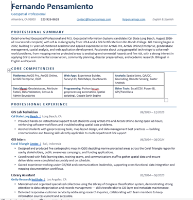
I'm Fernando Pensamiento, a California-based geospatial professional completing my M.S. in Geospatial Information Systems at Cal State Long Beach, with a B.A. in Geography from UCLA. I specialize in spatial analysis, cartography, remote sensing, and web mapping, building data-driven solutions that support environmental analysis, community planning, and informed decision-making.
My work spans real-world projects across two continents, from mapping Marine Protected Areas during my internship with the Coral Triangle Center in Bali, Indonesia, to analyzing toxic release sites near schools and wildfire hazard zones across Southern California. I'm comfortable working across the full GIS project cycle, from data cleaning and geoprocessing to publishing interactive dashboards and web applications using ArcGIS Pro, ArcGIS Online, and QGIS.
I care about making maps that are actually useful, not just visually impressive. Whether I'm supporting environmental conservation, disaster preparedness, or academic research, my goal is to translate complex spatial data into clear insights that help people make better decisions. I am bilingual in English and Spanish.
Education
Master of Science, Geospatial Information Systems
California State University, Long Beach — Expected August 2026
Bachelor of Arts, Geography (Emphasis in GIS)
University of California, Los Angeles — 2025
GIS Certificate, Geospatial Information Systems
Rio Hondo College — 2023
Associate of Science, Cybersecurity | Associate of Arts, Social Sciences
Rio Hondo College — 2023
Connect